
The SCBARS team is working on mapping sea level rise along the South Carolina coast.
Interactive Sea Level Rise Maps Made by SCBARS
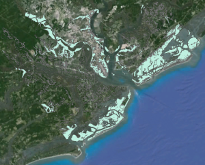
Click here to see the interactive sea level rise maps for the Charleston area.
Thus far, we have mapped the Charleston area with 1-, 2-, 3-, 4-, 5-, and 6 feet of sea level rise and have uploaded the data into online interactive maps at the following links:
- Charleston with 1 Foot Sea Level Rise
- Charleston with 2 Feet Sea Level Rise
- Charleston with 3 Feet Sea Level Rise
- Charleston with 4 Feet Sea Level Rise
- Charleston with 5 Feet Sea Level Rise
- Charleston with 6 Feet Sea Level Rise
To learn more about how much sea level will rise by when, please see here.